How We Work
The groundwater that Fort Huachuca and local communities use for homes, businesses, and agriculture is the same water source that keeps the San Pedro River flowing and sustains the riparian area. The water that local communities pump from the underground aquifer is the groundwater that seeps into the river as baseflow to keep it flowing during periods when there is no rain.
CCRN’s water management approach focuses on ways to ensure the right amount of water is available in the right locations at the right times. CCRN projects and sites increase groundwater recharge to the aquifer and conserve groundwater resources in the most strategic places, thereby helping to ensure both the health of the river and water security for communities. These projects and sites benefit the aquifer and river by recharging the aquifer, retiring historical pumping, and precluding future pumping with conservation easements that permanently restrict high volume pumping and large-scale developments.
Why Recharge?
Aquifer recharge is a process for storing water underground. In the case of the San Pedro River, recharge projects increase groundwater levels in key locations along 25 miles of the San Pedro River. These projects are helping nature replenish groundwater by storing more stormwater and treated effluent underground in locations where it will benefit the aquifer and river.
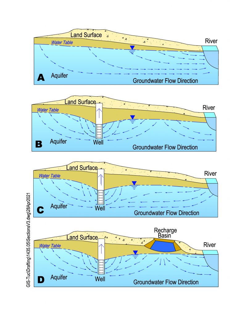
Figure A illustrates how groundwater is connected to streamflow in the river.
Figure B shows that groundwater pumping creates a “cone of depression” in the water table, increasing the depth to groundwater around large pumping centers. A cone of depression can initially reduce streamflow by intercepting groundwater that is flowing toward the river.
Over time, Figure C shows as the cone of depression expands toward the river, it can reverse water flow direction and “capture” or take water out of the river.
Figure D demonstrates how recharging water into the ground in key areas between a cone(s) of depression and the river, recharge basins can stabilize or even increase groundwater levels, minimizing pumping impacts on the river.
Hydrologic Monitoring and Modeling
CCRN relies on predictive hydrologic models and long-term monitoring to quantify and improve the design and effectiveness of CCRN projects and to address legal and regulatory compliance. Hydrologic monitoring of precipitation, surface water runoff, and groundwater levels is ongoing at CCRN project sites. Data collection is tailored to each site’s features and project goals, and data are evaluated annually to support design, improve operation, and track results.
Predictive models are used by CCRN to forecast how groundwater and surface water will respond to different management scenarios, including the potential location and design of future groundwater recharge facilities. The use of these technical tools helps to ensure that the best investments are made in projects to meet desired goals and objectives. They also help design projects for multiple benefits, such as those that decrease erosion and sedimentation while also increasing groundwater storage and baseflows of the San Pedro River.
Groundwater modeling also predicts how much streamflow is “captured” or “intercepted” by groundwater pumping in a specific location, which helps identify the best locations for recharge projects. Recharge projects along the river in the alluvial aquifer will most directly benefit the adjacent river.
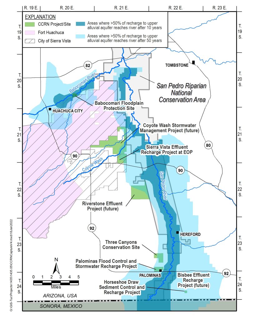
The blue area on the figure to the right shows the zone where projects can most effectively recharge and/or protect the aquifer to help the river and riparian corridor. The blue areas indicate areas where 50% or more of water that is recharged is expected to benefit the river within 10 and 50 years, respectively. The same can be said for water that is no longer pumped in this area; 50% of the water saved by retiring pumping will be made available to the river again within that same timeframe.
More Information
The best available science using hydrologic monitoring and inventories, and predictive models, together with engineering studies, have informed both these recharge and conservation measures to ensure that the most effective and feasible projects are implemented to best meet regional water needs. The Upper San Pedro Partnership website provides access to many of these studies and reports and also features a Web-based Hydrologic Information Portal (WHIP) populated with water data gathered by local, state, and federal agencies and organizations since 1904.
The following USGS publications provide more information on groundwater and water availability in the Western United States:


